 National Parks of China
Overview
| Designation | US National Park |
| Location | Northern Alaska |
| Latitude, longitude | 67.8, -153.4 Google Maps |
| Area | 8,500,000 acres |
| Nearby cities | Fairbanks, AK |
| Nearby sites | Kobuk Valley National Park, Denali National Park and Preserve |
| Themes | Glacier, Lake, Wildlife, Mountain, River |
About
Gates of the Arctic National Park is in northern Alaska. It became a US national park in 1980.
Travel tips
Getting there: the park lies north of the Arctic Circle and has no roads, trails or visitor facilities. The nearest large city is Fairbanks; small planes go from there to villages such as Bettles, and visitors then charter a flight into the park.
By road: the Dalton Highway runs north from Fairbanks along the eastern edge of the park, through Coldfoot, and is the easiest way to the park boundary.
Visitor centres: Bettles and Coldfoot both have visitor contact stations, open in summer, where you can discuss routes and equipment.
How to visit: most visitors backpack, float rivers or fly by charter into wilderness valleys; there are no marked routes, so you need wilderness experience or a guide.
Rivers: the John, Alatna and other rivers can be floated; plan pick-up times with the charter pilot in advance.
Season: summer (June to August) is best, with very long days and the most mosquitoes; snow begins in September, when the aurora can be seen.
Time: allow at least a week; charter flights are often delayed by weather, so leave slack in your schedule.
Where to stay: inside the park there is only wilderness camping; Bettles and Coldfoot have simple lodges.
Caution: grizzly bears live here, so keep food in bear-resistant containers; carry a satellite phone or locator beacon and tell the park office your route.
More photos
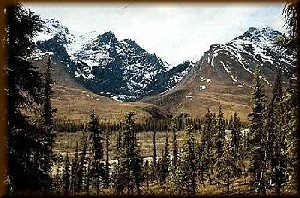
Photo credits: Gates of the Arctic National Park: US National Park Service, Alaska Region (public domain)