National Parks of China
Overview
| Designation | National Park of China (fifth batch) |
| Province | Guizhou |
| Location | Liping County, south-east Guizhou |
| Latitude, longitude | 26.2, 109.1 Google Maps |
| Highlights | Karst |
| Nearby cities | Guizhou, Guangxi, Guilin and the Li River, Guiyang, Fenghuang |
| Nearby sites | Guilin and the Li River, Libo and the Zhangjiang River, Mount Doupeng and the Jian River, Duyun, Wuyang River, Mount Lang (Langshan), Rongjiang, Mount Wanfo and the Dong Villages, Nanshan |
| Themes | Karst, Rivers, Natural bridges, Stamps |
About
The Liping Dong Villages scenic area in Liping County, south-east Guizhou, has three parts: the Bazhou River scenery, the historic sites of the county town and the Dong customs of Zhaoxing. It includes the drum towers of Zhaoxing, the largest Dong settlement in China, and the famous Diping wind-and-rain bridge.
The Bazhou River area around Gaotun township, 16 km north-east of the county seat, is karst, with Xianren Rock, the Shaozhai caves, Osmanthus Terrace, Luci Rack and a river island.
The Liping natural bridge, 1 km south-east of Gaotun, spans 104 m, is 118 m wide and 33 m above the river, with a rock layer about 40 m thick over the arch.
Xianren Rock on the river bank about 3 km from Gaotun has four stones standing on top and a cave of about 800 m² at its foot. Osmanthus Terrace on the east bank is 40 m high with hundreds of wild osmanthus trees.
Stamps
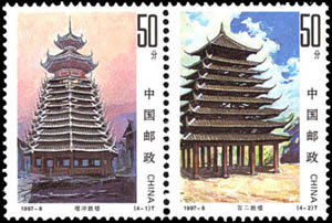
On 22 June 1997 China Post issued 1997-8 “Dong Architecture”, four stamps: the Zengchong and Bai’er drum towers and wind-and-rain bridges over a river and among fields.