National Parks of China
Overview
| Province | Chongqing |
| Location | Chongqing |
| Latitude, longitude | 29.5, 106.5 Google Maps |
| Nearby sites | Dazu Rock Carvings, Chishui, Furong River, Wulong, Mount Jinyun |
| Nearby cities | Chengdu, Xi’an, Guiyang |
| Themes | Metropolises, Great rivers, Hills, Cable cars, Stamps |
About
Chongqing lies in the eastern Sichuan basin where the Jialing joins the Yangtze, among hills and frequent fog, hence “Mountain City” and “Fog Capital”; its short name is Yu. On 14 March 1997 it became China’s fourth municipality.
City sights
Chaotianmen docks
Eling Park
Liberation Monument
Chongqing Zoo
The city gates
Suburban sights
Mount Jinyun, Northern Hot Springs
Further afield
Baiheliang inscriptions
News
On 18 February 2008 the Hugui Rock in the Danzishi reach off Chaotianmen was blasted away; originally “Turtle Rock”, it carried the legend of Yu the Great taming the floods.
In July 2007 torrential rain flooded Chongqing, killing at least 50.
Stamps
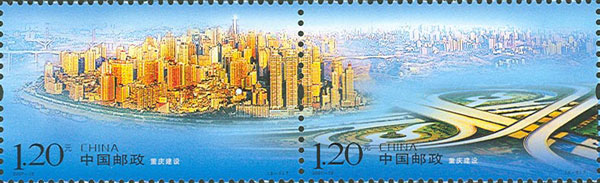
On 8 June 2007 China Post issued 2007-15 “Construction of Chongqing”, two stamps: the new look and the transport network.