 National Parks of China
Overview
| Designation | National Park of China (first batch) |
| Province | Heilongjiang |
| Location | Mudanjiang, Heilongjiang |
| Latitude, longitude | 43.9, 128.9 Google Maps |
| Highlights | Volcanic landscape |
| Top sights | The underground forest, the lava caves |
| Area | 90 km² |
| Nearby cities | Shenyang, Harbin, Changchun |
| Nearby sites | Songhua Lake, Xianjingtai, Fangchuan, Heaven Lake of Changbai Mountain |
| Themes | Lakes, Volcanoes, Forests, Caves, Waterfalls, Stamps |
About
Jingpo Lake, near Mudanjiang in Heilongjiang, is a lake dammed by volcanic lava, long and narrow, about 45 km north to south and about 90 km² in area, with the Big and Little Solitary Hills, Pearl Gate and Taoist Hill.
The Diaoshuilou Waterfall at the north end is 25 m high and 43 m wide. The “underground forest”, primeval forest growing inside old volcanic craters, lies about 50 km north-west; the lava caves, formed by cooling lava, about 30 km north-west.

Jingpo Lake was formed about 10,000 years ago when lava from volcanic eruptions dammed the Mudan River: the largest mountain barrier lake in China, 350 m above sea level and over 60 m deep, its water clear as a mirror, hence the name. On the lava dam at the north end the Diaoshuilou Falls are China’s largest lava waterfall, 300 m wide in high water and only a few threads in the dry season. The crater forest north-west of the lake is one of the best-preserved primeval crater forests in the world. Near the lake lie the ruins of Shangjing Longquanfu, capital of the Tang-era Bohai (Balhae) kingdom for 200 years.
It is in the first batch of national parks of China (national scenic areas) named by the State Council in 1982.
Travel tips
Getting there: first go to Mudanjiang, which has high-speed trains from Harbin and elsewhere. A bus from Mudanjiang to the lake takes about two hours.
Diaoshuilou Falls: at the north end of the lake, not far from the north gate. The flow is strong after summer rain and small in dry spells.
On the lake: boats leave from the northern pier and head south; there are longer and shorter routes, the short ones covering only the nearer part of the lake. In winter the lake freezes and boats stop.
Underground Forest: on a separate road north-west of the lake; allow a separate half day.
Bohai capital ruins: at Bohai town in Ning'an, not far from the lake and easy to combine with it.
Time: one day for the lake and the falls, plus half a day to a day for the crater forest.
Season: June to September is best for the boats and the falls; winter is very cold, with ice fishing and snow activities.
Where to stay: in hotels by the lake, or back in Mudanjiang or Ning'an.
Main sights
Diaoshuilou Falls: at the north end, dropping into the 70 m Black Dragon Pool; in summer divers leap the falls.
Boat trips: from the northern pier south past Dagushan, Xiaogushan, the Wall Rocks, Pearl Gate and Taoist Hill to the southern end.
Underground forest of the craters: in the Zhangguangcai range 50 km north-west, ten craters filled with Korean pine and fir; stone steps lead from the crater rim to the floor.
Ruins of Shangjing Longquanfu: at Bohai town, Ning’an, north-east of the lake, with well-preserved walls, palace foundations and the stone lantern of Xinglong Temple; a national protected site.
Lava caves: lava tunnels on the plateau north-west of the lake with lava stalactites and ice.
Map
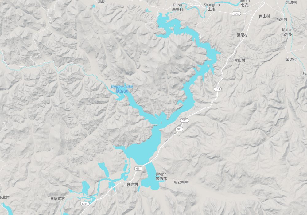
© OpenStreetMap contributors · terrain © Copernicus · Map credits