 National Parks of China
Overview
| Designation | UNESCO World Heritage (cultural, 2000) National Park of China (first batch) AAAAA tourist attraction |
| Province | Sichuan |
| Location | Sichuan |
| Latitude, longitude | 31.0, 103.5 Google Maps |
| Highlights | Taoist mountain; irrigation works of the Warring States period |
| Highest point | 1,260 m |
| Nearby cities | Chengdu, Chongqing, Guiyang, Lanzhou |
| Nearby sites | Mount Siguniang and the Sichuan Giant Panda Sanctuaries, Mount Emei and the Leshan Giant Buddha, Jiuzhaigou and Huanglong, Xiling Snow Mountain, Mount Longmen, Mount Tiantai, Qionglai |
| Themes | Famous mountains, Mountains, Taoism, Temples, Rivers, Culture & history, Stamps, Cable cars |
Mount Qingcheng
Mount Qingcheng, a famous Taoist mountain, lies about 10 km south-west of Dujiangyan (formerly Guan County) in Sichuan. Known as “the most secluded under heaven”, it is one of the four great sights of Sichuan. Its highest peak, Laoxiaoding, is 1,600 m.
Dujiangyan
Dujiangyan, on the Min River west of the city, is a large irrigation system begun around 250 BC by Li Bing, governor of Shu for the state of Qin, and his son, and still in use today.
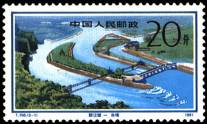
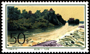
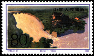
In 1991 China Post issued “Dujiangyan Irrigation Works”, three stamps: the Fish Mouth levee, the Flying Sand weir and the Bottle-Neck channel.
News
At 14:28 on 12 May 2008 a magnitude 7.8 earthquake struck Wenchuan County, Sichuan, with its epicentre near 31°N 103.4°E; it was felt across many provinces and by that evening 8,533 deaths had been reported in Sichuan alone. Dujiangyan was badly hit, with many rockfalls.