 National Parks of China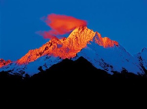
Overview
| Designation | UNESCO World Heritage (natural, 2003) National Park of China (second batch) |
| Province | Yunnan |
| Location | North-west Yunnan |
| Latitude, longitude | 26.9, 100.0 Google Maps |
| Highlights | High mountains and gorges; wildlife |
| Top sights | Meili Snow Mountain, Tiger Leaping Gorge |
| Wildlife | Golden snub-nosed monkey, clouded leopard, red panda, goral; Taiwania, Chinese Douglas fir, Yunnan yew, Gongshan plum-yew, Tetracentron, dove tree |
| Area | 40,000 km² |
| Highest point | 6,740 m |
| Nearby cities | Yunnan, Jade Dragon Snow Mountain and Lijiang, Chengdu, Kunming |
| Nearby sites | Jade Dragon Snow Mountain and Lijiang, Qionghai Lake and Mount Luoji, Mount Gongga (Minya Konka), Dali, Stone Forest of Lunan, Mount Emei and the Leshan Giant Buddha, Mount Qingcheng and the Dujiangyan Irrigation System, Mount Siguniang and the Sichuan Giant Panda Sanctuaries |
| Themes | Mountains, Great rivers, Snow mountains, Forests, Canyons, Plants, Animals, Lakes, Cliffs |
About
The Three Parallel Rivers lie in the Hengduan Mountains of north-west Yunnan, where it borders Sichuan and Tibet. From east to west the Jinsha (upper Yangtze), Lancang (upper Mekong) and Nu (upper Salween), all rising in the Tanggula Mountains of the Tibetan Plateau, run side by side from north to south for 400 km. At their closest the Lancang and Jinsha are 66 km apart, the Lancang and Nu 16 km. The rivers follow deep faults, cutting three great gorges; their beds step down from east to west, the Jinsha at 2,100 m, the Lancang at 1,900 m and the Nu at 1,600 m.
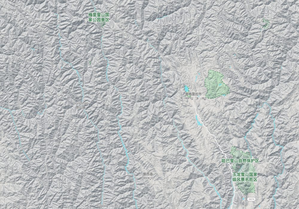
The scenic area spans Nujiang Lisu Autonomous Prefecture, Yulong Naxi Autonomous County and Diqing Tibetan Autonomous Prefecture, between 98° and 100°30′ E and 25°30′ and 29° N, about 40,000 km² with a core of about 10,000 km².
Its many gorges include the Nu River Grand Canyon, Tiger Leaping Gorge on the Jinsha, the Shuangnawadi and Qingladi gorges of the Nu, and the Huangdengyan and Fulongqiao gorges of the Lancang.
It is in the second batch of national parks of China (national scenic areas) named by the State Council in 1988.
Main sights
<b>Tiger Leaping Gorge</b>: on the Jinsha River between Lijiang and Shangri-La, in upper, middle and lower sections. By legend a tiger crossed the river by leaping on a rock in midstream. The gorge is narrow at its mouth, with Jade Dragon Snow Mountain on one side and Haba Snow Mountain on the other, and is among the deepest in China.
<b>Shigu and the First Bend of the Yangtze</b>: around Shigu town in Yulong County, Lijiang. The Jinsha River arrives from the north and turns northeast here, forming what is called the First Bend of the Yangtze.
<b>Jade Dragon Snow Mountain</b>: north of Lijiang, with the main peak, Shanzidou, at 5,596 m and modern glaciers. Spruce Meadow and Blue Moon Valley lie at its foot.
<b>Haba Snow Mountain</b>: on the north bank of Tiger Leaping Gorge, with the main peak at 5,396 m, a destination for hiking and mountaineering.
<b>Baima Snow Mountain</b>: in the south of Deqin County, a national nature reserve and the main habitat of the Yunnan snub-nosed monkey. The road crosses the ridge at a pass about 4,300 m high, through spruce and fir forest and alpine meadow.
<b>Meili Snow Mountain and Mingyong Glacier</b>: in Deqin County, with the main peak Kawagebo at 6,740 m. Mingyong Glacier flows down into the forest, and its tongue ends at a very low elevation, among the lowest-latitude and lowest-altitude glaciers in China.
<b>Feilai Temple</b>: near Deqin, facing the Thirteen Peaks of Meili. It is a common viewpoint for sunrise light on the snow peaks.
<b>Shangri-La</b>: the prefecture seat of Dêqên (Diqing) Tibetan Autonomous Prefecture, with the old town of Dukezong and Songzanlin Monastery. To the east, Potatso National Park has lakes and forest around Shudu Lake and Bita Lake.
<b>Nujiang Grand Canyon and Bingzhongluo</b>: in the west of Nujiang Prefecture, where the Nu River runs between the Gaoligong and Biluo mountains. The First Bend of the Nu River is near Bingzhongluo, a village at the northern end of the Nujiang road.
<b>Laojun Mountain</b>: in Lijiang, with Danxia landforms and alpine rhododendrons, one of the component areas of the World Heritage site.
Geology and landscape
The Hengduan Mountains are a series of roughly north-south ranges and gorges raised by the collision of the Indian and Eurasian plates. In the Three Parallel Rivers area, several great rivers run south along fault zones, held in narrow strips between high ranges.
Ranges and rivers alternate: the Yunling range lies between the Jinsha and Lancang rivers, the Biluo range between the Lancang and Nu, and the Gaoligong range to the west of the Nu. Many peaks exceed 4,000 m while the rivers lie only one or two thousand metres above sea level, so the gorges are very deep.
Several of the high mountains carry modern glaciers. Mingyong Glacier on Meili descends into the forest, and the glaciers on Jade Dragon Snow Mountain have retreated noticeably in recent years. These are maritime glaciers at low latitude, with heavy snowfall and rapid melt.
Around Laojun Mountain the landscape is Danxia, formed in red sandstone, different from the snow peaks and gorges. In the valleys of the Jinsha and Lancang there are dry, hot valleys with sparse vegetation, in strong contrast with the fir forests higher up.
Travel tips
Getting there: Lijiang and Shangri-La have airports, and a railway links Lijiang and Shangri-La, about an hour and a half by bullet train. The Three Parallel Rivers area is very large; travel between sites is mostly by road, over long distances and mountain routes, so a hired car or tour is common.
Tiger Leaping Gorge: on the Jinsha River between Lijiang and Shangri-La. Upper Tiger Leaping Gorge is beside the road and reached by car; the high trail along the gorge is a one- to two-day hike.
Meili Snow Mountain: in Deqin County; the area around Feilai Temple is the usual viewpoint. Yubeng village lies deep in a valley; hike in from Xidang or Ninong, or take the shuttle bus from Xidang to Nanzong Pass or Upper Yubeng (trial service since late September 2026; private cars are not allowed into the village), and allow two or three days.
Nu River: the Nu River Gorge is in the west and takes longer to reach; Bingzhongluo is the usual end point.
Time: Tiger Leaping Gorge alone can be a day trip; adding Meili takes at least four or five days; several areas need a week or more.
Season: October to April is drier, with better chances of seeing the snow peaks; the summer rainy season brings landslides and road closures.
Caution: Shangri-La and Deqin are at high altitude, and the Baima Snow Mountain area is higher still; take it slowly on arrival to avoid altitude sickness.
Where to stay: Lijiang and Shangri-La are the usual bases; Deqin, Feilai Temple and Bingzhongluo also have accommodation.
The three rivers
The Jinsha is the upper Yangtze from the mouth of the Batang River in Yushu, Qinghai, to Yibin in Sichuan. At Shigu in Yulong County, Lijiang it swings sharply north and below Jade Dragon Snow Mountain carves the famous Tiger Leaping Gorge, more than 3,000 m deep.
The Lancang is the upper Mekong; its headstreams, the Zaqu and Jiqu, rise in the Tanggula Mountains and join at Chamdo in Tibet. It flows through western Yunnan and leaves China in the south of Xishuangbanna for Laos as the Mekong. Its main stream in Yunnan is 465 km long.
The Nu rises on the southern slope of the Tanggula Mountains and leaves China in Dehong prefecture for Myanmar as the Salween. In the Three Parallel Rivers area it races between the Gaoligong and Biluo ranges, whose crests exceed 3,000 m, the highest point 5,060 m and the lowest 760 m.
Shangri-La
Zhongdian, in Diqing Tibetan Autonomous Prefecture, was renamed Shangri-La County in 2001 (a county-level city since 2014) after the fictional valley in James Hilton’s novel Lost Horizon.
In 2007 the Shangri-La ski resort opened in Nixi township: the first phase has beginner and intermediate runs 1,400 m long and 40 to 90 m wide for up to a thousand skiers; when all three phases are complete it will have three lifts, 10 beginner runs and 14 each of intermediate and advanced runs.
Meili Snow Mountain
Meili Snow Mountain belongs to the Nu range in the middle of the Hengduan Mountains, on the border of Deqin County, Yunnan, and Zayü County, Tibet. It joins the Adonggeni range to the north and the Biluo range to the south, with thirteen peaks above 6,000 m, the Thirteen Prince Peaks. The main peak, Kawagebo, at 6,740 m is the highest in Yunnan and the first of the eight sacred mountains of Tibetan Buddhism.
The area also has Jade Dragon Snow Mountain (5,596 m), Haba Snow Mountain (5,396 m), Baima Snow Mountain (5,429 m) and more than 60 peaks over 4,000 m in the Biluo, Gaoligong and Laojun ranges.
Wildlife
The area is one of the richest in biodiversity on earth and an important gene bank, concentrating the climates and communities of the south, middle and north subtropical, warm temperate, temperate, cold temperate and cold zones of the northern hemisphere. With south-east Yunnan–north-west Guangxi and western Sichuan–western Hubei it is one of China’s three centres of biodiversity.
It is estimated to hold some 200 families, 1,000 genera and 5,000 species of higher plants, over a third of Yunnan’s, a sixth of China’s and a sixtieth of the world’s. There are 173 mammal, 417 bird, 59 reptile, 36 amphibian, 76 freshwater fish and 31 swallowtail butterfly species, each more than a quarter of China’s total.
Rare plants include Taiwania, Chinese Douglas fir, Yunnan yew, Gongshan plum-yew, Tetracentron and the dove tree; rare animals the golden snub-nosed monkey, clouded leopard, red panda and goral.
At Luding Xinzhu in Lijiang County several thousand plant species grow within less than 10 km², a natural botanical garden of the Hengduan Mountains. More than 400 rhododendron species, a quarter of the world’s, grow on the Gaoligong, Biluo and Laojun mountains.
Peoples
Fourteen ethnic groups live here, among them the Lisu, Tibetans, Naxi, Nu, Derung, Bai and Yi, 59% of Yunnan’s 24 groups.
Map
© OpenStreetMap contributors · terrain © Copernicus · Map credits